Managing the Impacts of Tectonic Hazards
Specification link
This page covers section 4.4.1 and 4.4.2 of the CIE O Level specification.
4.4.1 - Primary and secondary responses.
4.4.2 - An evaluation of the strategies and techniques used to manage the impacts of earthquakes and volcanic eruptions: monitoring, prediction, protection, planning and technology.
Primary and secondary responses
Primary and secondary responses
Types of response to tectonic hazard
The responses to any tectonic hazard can be divided into two groups
Immediate or emergency
Long term
Immediate or emergency responses
The immediate or emergency response is the action taken immediately after a hazard event, such as an earthquake
Rescue teams search for survivors
Medical assistance for injured people
Shelter provided for those people made homeless
Food and water provided
Recovery and burial of bodies
Evacuation if needed
Clearing ash and debris
Reconnect gas, water and electricity supplies
This response has to be coordinated, as many NGOs and government organisations, including the armed forces, may be involved
Long term responses
The long-term responses happen over the months and years after the hazard
Rebuilding homes and other buildings
Improve building regulations
Improve drills, evacuation plans and warning systems
Money given to farmers for seed and new livestock
Data used to inform future hazard planning
Government planning improved
Transport routes rebuilt
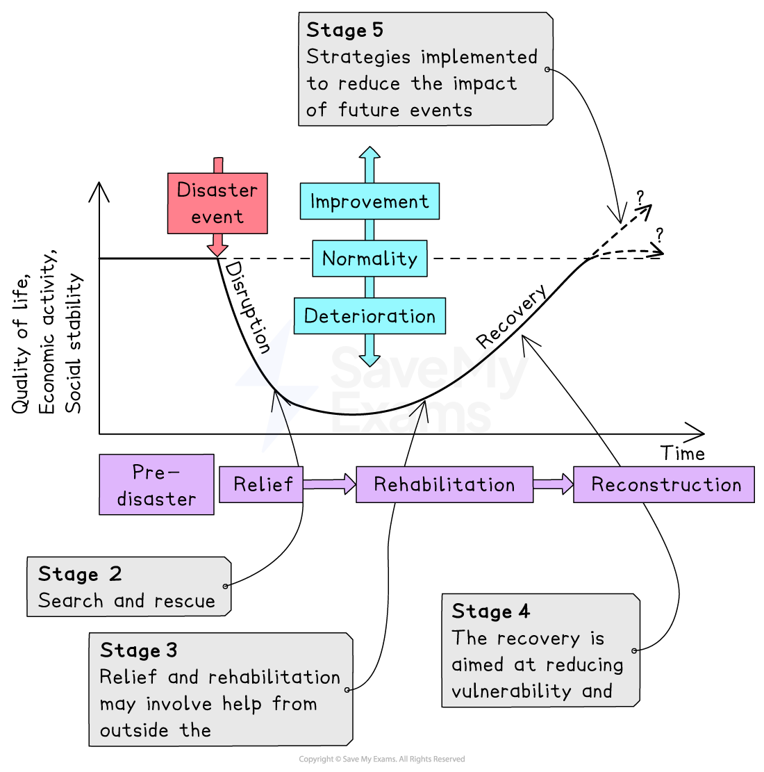
Park's hazard response curve
The stages of hazard response can be seen in Park's hazard response curve
Strategies to manage the impacts of tectonic hazards
Strategies to manage the impacts of tectonic hazards
To reduce the risks from tectonic hazards, the five key management strategies and techniques are:
monitoring
prediction
protection
planning
technology
Monitoring
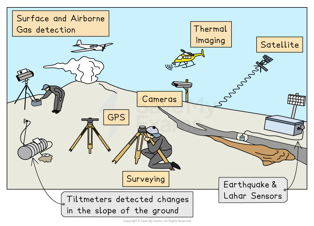
Active volcanoes are monitored using a range of equipment
Seismometers record earth movements and can detect the slightest tremor
Lasers and tiltmeters are used to detect ground deformation; changes in land shape can be a sign of rising magma
Remote sensing is where satellites are used to detect heat increases within the volcano, another sign of rising magma
Gas sensors detect increases in gases such as sulphur and radon which increase before an eruption
Earthquakes
Seismometers record earth movements and can be used to detect foreshocks
Gas sensors detect increases in radon gas, which some scientists believe is released before an earthquake
Groundwater level changes have been recorded before earthquakes
Prediction
Volcanoes:
Monitoring of volcanoes now allows more accurate predictions to be made of when eruptions will happen
This allows for evacuation and exclusion areas to be put in place
Accurate timings for eruptions are not possible
Earthquakes:
Impossible to predict the date, time or location because it is a very sudden release of stress that has built up over long periods
Protection
Volcanoes:
Evacuation and exclusion zones move people out of areas at risk
Buildings cannot be protected against lava or pyroclastic flow
Strengthening of roofs to support the weight of falling ash
Airports can be closed to ensure that planes are not flying through ash clouds
In June 2025, Bali's international airport was closed due to the eruption of Mount Lewotobi Laki-Laki
Earthquakes:
Building regulations and codes require new buildings to include earthquake-resistant features, including:
shutters on windows prevent falling glass
cross-bracing or diagonal bracing of steel frames
flexible building materials
foundations sank deep into the bedrock
frames which sway with the earthquake tremors
rubber shock absorbers to reduce tremors moving through the building
reinforce walls/pillars with concrete
shatterproof/reinforced glass
fire-resistant materials
automatic cut-off for gas/electricity
In many countries, earthquake drills are regularly carried out
The drills help people prepare for what to do in an earthquake to protect themselves
Educating people about how to prepare homes means they are less likely to be injured by falling objects and furniture
Sea walls to protect against tsunami
Planning
Volcanoes and earthquakes:
Hazard mapping and risk assessment are used to identify areas which are at greater risk – this means people can be moved or buildings restricted in those areas, particularly essential buildings (hospitals) and transport
Evacuation plans
Education about what actions to take, including drills
Stockpile of emergency supplies
Training of emergency services
Technology
Hazard mapping and geographical information systems (GIS) can be used to:
Map the areas where earthquakes are most likely to occur
Enable planning of where important services and infrastructure should be located – land use zoning
Identify the correlation between risk and vulnerability
Remote sensing of the Earth's surface by satellites such as Sentinel 1 provides data about changes in ground movement