1.6.1 Characteristics of Urban Land Use
Land Use in Urban Areas
Land Use in Urban Areas
Urban land use
This refers to activities that are found in towns and cities
All urban settlements have recurring features:
A central core or central business district (CBD)
Industrial areas - inner-city ring
Different residential districts - suburban ring
Outer zones of suburban expansion - urban fringe
All towns and cities tend to grow outwards, from a historic centre or core to an urban fringe
Each zone grows due to the needs of the city during its development, over time
As a general rule, all towns and cities, regardless of place or level of development, show the same four features:
A central core
An inner-city zone
A suburban zone
An urban fringe
Central Core
The oldest part of a city with features such as:
The central business district (CBD) e.g. banks, retail and commercial offices
Multi-storey development, with vertical growth rather than horizontal due to lack of space
Land of high value
Concentrated retail and office space
Pedestrianisation for high footfall
Convergence of public transport
Traffic restrictions for private vehicles
Low residential population
Inner city zone
A 'frame' to the inner core which developed as the core developed
Older, compact, terraced 'worker' housing to support a growing population density
Surrounded by older industrial areas
Areas are centred around transport links and access to manufacturing
Available land increases with distance, so costs are reduced
Residential land is in direct competition with commercial usage
Suburban zone
Residential areas
Emergence of segregated residential zones based on wealth, ethnicity, choice or government policy (e.g. social housing)
Semi and detached housing with gardens
Tree-lined avenues and cul-de-sacs
Smaller retail premises
The cost of land decreases but the size of the property increases with the distance
Urban fringe
Outer edges of the city:
The countryside is eroded through the urban spread/sprawl
Housing is clustered into estates, which increases 'spot' density
Some industrial land uses
Accessibility is best
Other similar characteristics of modern urban settlements include:
The age of the built-up area decreases from the core to the fringe
The density of building developments decreases from the core to the fringes
Grandeur, function, design and style changes across the zones
Over time, population density and land use changes
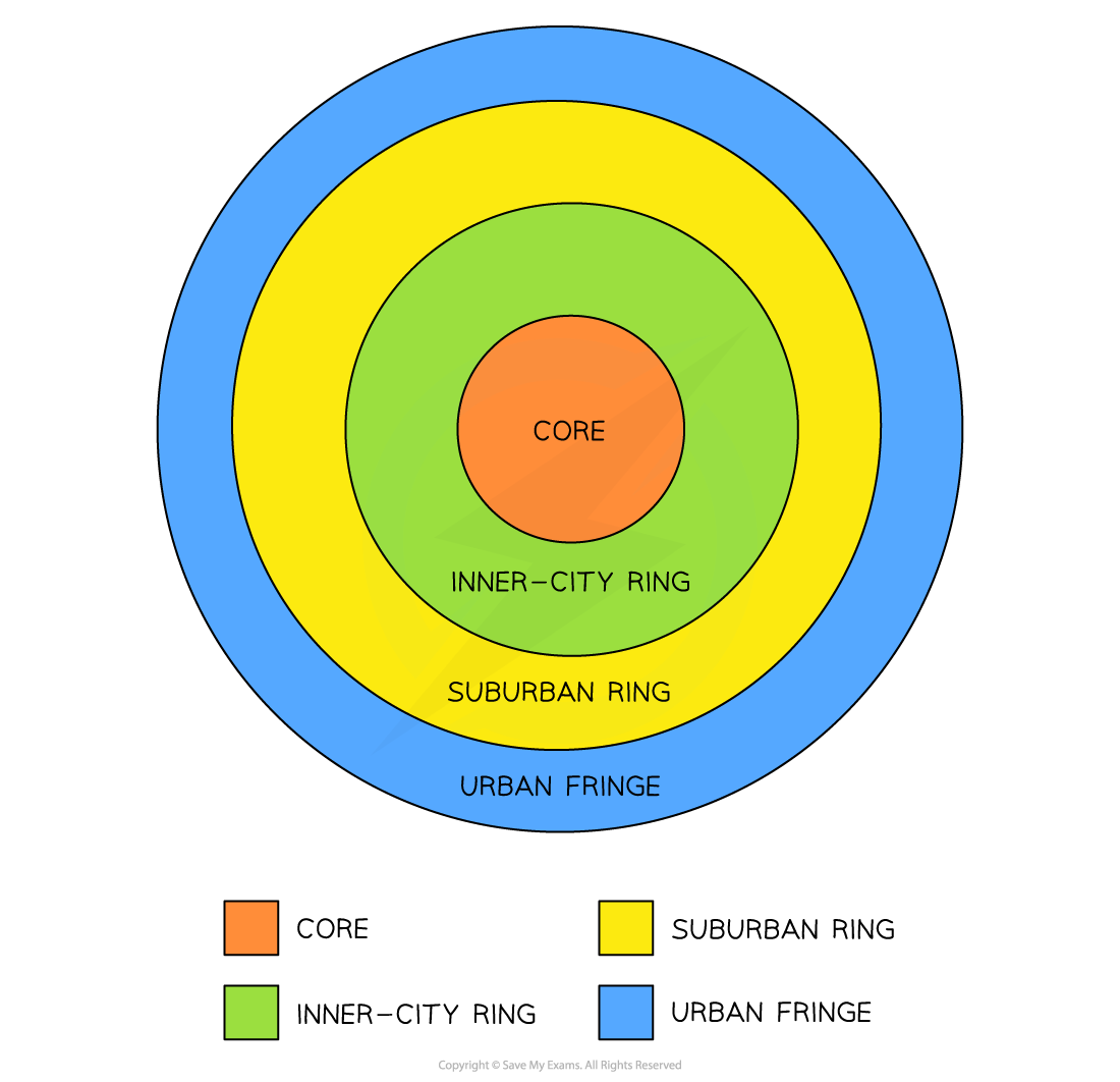
Based on Burgess's Concentric Ring Theory
The model above is a simplification but shows there is a core where most of the commercial activity is found
The CBD is usually the most accessible (public transport) with the highest land value
High-rise buildings are seen here due to the high demand for land, but there is a lack of space to satisfy that demand e.g. Singapore, New York and Hong Kong are known for their 'skyscrapers' and land prices are amongst the highest in the world
Peak land value
Any land that has 'purpose' will be valuable and cost more to buy or rent
Usually, retail shops can make money and seek prime positions
Therefore, land uses of similar activities will come together creating 'peaks' and 'troughs' of land values across the urban landscape
There are two points to consider:
The value of the land:
Varies across the urban areas
Usually decreases from the centre, outwards
Higher land prices are also found along main roads, urban hubs and around ring roads
The location of the land:
Is important to value
The closer to key functions, the higher the value
Accessibility and desirability increase land value
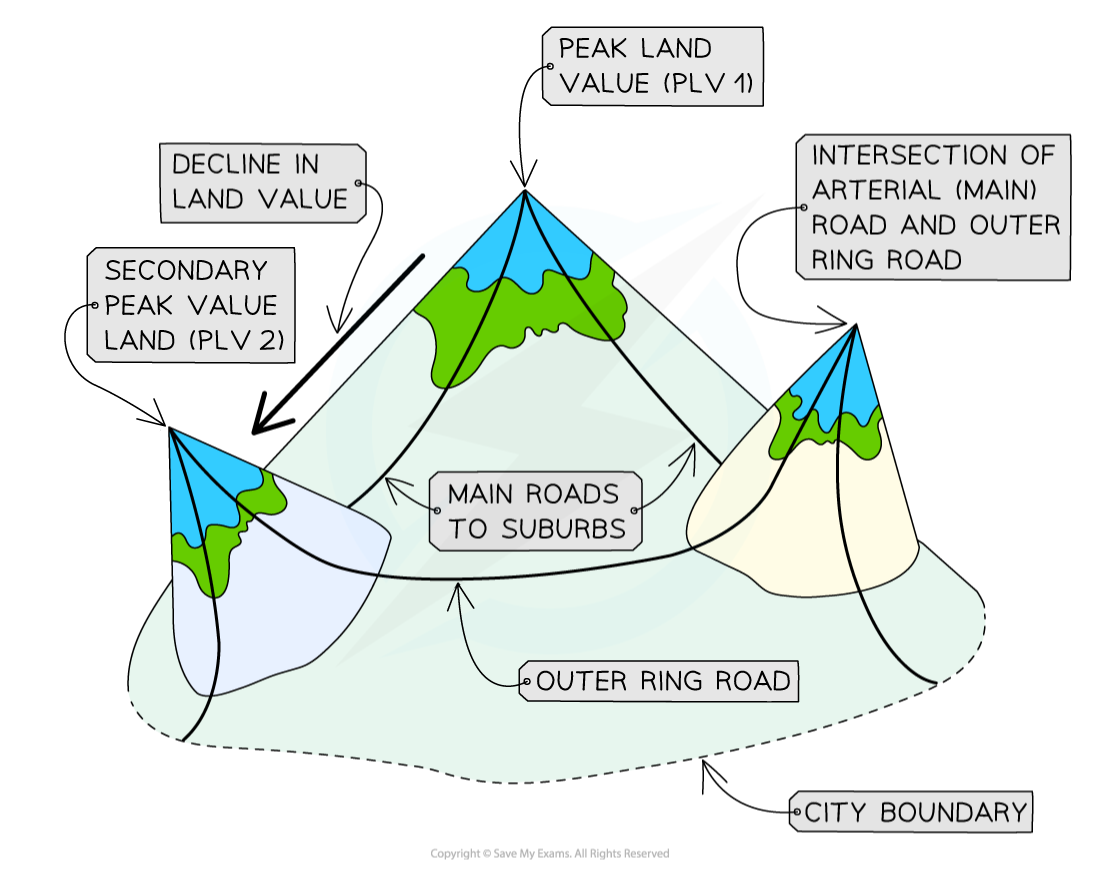
Peak Land Value
Bid-rent theory
Also known as 'distance decay theory', where the price and demand for land change as the distance from the CBD increases
Different land uses will compete for desirable plots to maximize their profits
Accessibility increases the potential for more customers
There is a trade-off between accessibility and the cost of the land
The closer to the CBD the more desirable land is to retail and the higher the price charged/paid
Industry cannot compete with high prices moving further away from CBD
Residential land is outpriced across the zones, but competition is less so value decreases as more space becomes available
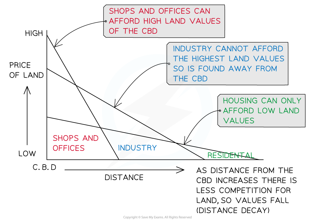
Bid-Rent Theory
Urban land use in LEDCs
The Latin American city model shows that the CBD has developed around a colonial core, with a commercial corridor extending from it
This has become the main avenue and contains open spaces and homes for medium and higher-income earners
These areas will have quality streets, schools and public services
Newer suburbs are found further out with random housing and fewer services
Squatter housing is found at the edge of the city; however, the more established squatter settlements can be found along the zones that extend into the city centre
Conditions here are usually better than in the more recent housing at the edge, most likely due to employment opportunities found closer to the core
Industrial areas are scattered along the major transport routes, with the newest developments at the edge

Latin American City Model
Land zoning in LEDCs
Manufacturing is found throughout the city
Segregation is seen through wealth, ethnicity and race
The wealthy are found closer to the central core of the city on wealthy land
The poor are pushed to the peripheral areas