Detailed Specific Example: Ganges/Brahmaputra
Specification link
This page covers section 1.3.8 of the CIE O Level Geography specification.
1.3.8 - One detailed specific example to include:
the causes and impacts of a flood for a named river.
the strategies and techniques used to manage the flooding of the river; including sustainable.
Causes of flooding in Bangladesh
Causes of flooding in Bangladesh
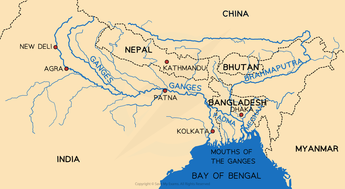
The Ganges is 2,510 km long
It flows through India and Bangladesh, where it becomes the River Padma and joins with the Brahmaputra River
The drainage basin covers 1.2 million km2
The population living within the area drained by the Ganges is over 650 million people
The Brahmaputra River is 3,969 km long
It flows through Tibet, India and Bangladesh, where it joins with the River Padma
The drainage basin covers 651,334 km2
Both rivers;
Have their source in the Himalayan Mountains
Waters enter the sea in the Bay of Bengal
Human causes of flooding
Deforestation, particularly in the upland areas
This leads to less interception and infiltration, increasing overland flow
Human-induced climate change has led to increased melting of Himalayan snow and ice, which increases discharge
It may also have affected climate patterns, leading to increased frequency and severity of tropical cyclones
Urbanisation, as the population increases and there is more rural-urban migration, leads to increased overland flow due to impermeable surfaces
Agriculture increases overland flow and soil erosion, which reduces the capacity of the rivers
Natural causes of flooding
Low-lying land in the Ganges delta in Bangladesh which is at or just above sea level, meaning that it floods more easily
Monsoon climate, which means that there are heavy and prolonged rains for some months
Tropical cyclones bring heavy rainfall
Melting snow and ice from the Himalayas in spring leads to a rapid increase in river discharge
Impacts of flooding in Bangladesh
Impacts of flooding in Bangladesh
The Ganges/Brahmaputra drainage basin regularly experiences floods, including most recently in May -July 2024 impacting approximately 40% of the population
In July 2019, approximately one third of the country was underwater
More than 360,000 homes were destroyed
Approximately 5 million people were directly affected
Landslides damaged roads and infrastructure
Waterborne diseases such as malaria increased
Cox's Bazaar was severely affected displacing over 6,000 refugees
'Normal' floods are vital to provide fertile soil and irrigation, but increasingly flooding is becoming more unpredictable and extensive
Strategies to manage flooding in Bangladesh
Strategies to manage flooding in Bangladesh
Bangladesh is a Low Income Country (LIC)
The country lacks the money for large schemes to reduce the impact of flooding
The World Bank and several high-income countries (HICs) funded the Flood Action Plan (FAP). The proposal included the following measures:
monitoring of flood levels
construction of levées/embankments
building 5000 flood shelters
creating floodwater storage systems
a more effective flood warning system
building of dams to store water
reducing deforestation
The FAP was not seen as a success because
Many parts of the project were never completed, including the dams and floodwater storage areas, due to inadequate funding and corruption
There was later a recognition that some flooding was necessary to maintain agriculture in many areas
Over 8 million people were forced to move to accommodate the FAP construction
Changing the channel upstream meant that areas downstream suffered more
The government cannot afford the maintenance costs
New management suggestions include:
Better flood forecasting and warning systems
More well-stocked flood shelters
These are less damaging to the environment and cheaper to maintain than hard engineering such as embankments, dams and floodwater storage areas