2.3.2 Coastal Landforms
Erosional Landforms
Erosional Landforms
Cliffs and wave-cut platforms
Cliffs are steep or sloping rocks, with varying profiles dependent on geology and topography
The cliff face angle also depends on geology, but also wave attack at its base - low energy waves are less destructive than high energy ones
Many cliffs have a 'knick-point' around the high-water mark, called the 'wave-cut notch', which is where the wave has undercut the rock
Abrasion, corrosion and hydraulic action further extend the notch back into the cliff
As undercutting continues, the cliff above becomes unsupported and unstable and eventually collapses
The backwash of the waves, carries away the eroded material, leaving behind a wave-cut platform
The process repeats and the cliff continues to retreat, leading to a coastal retreat
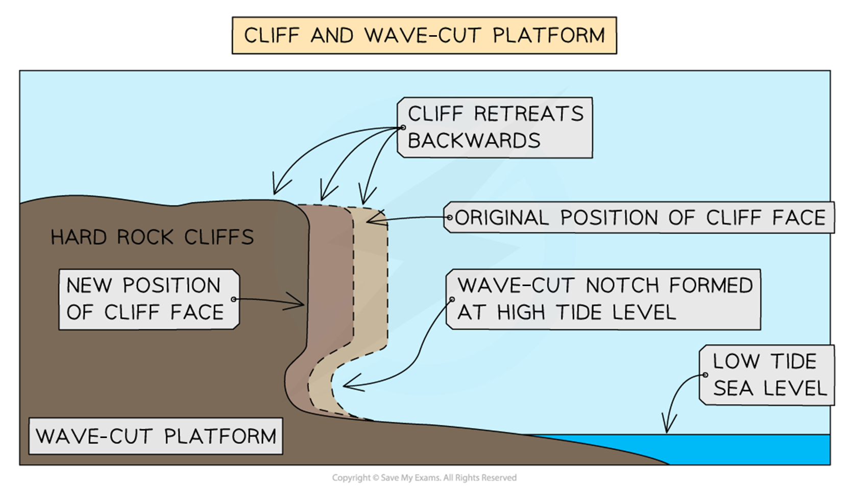
The process of cliff retreat and wave-cut platform formation
Headlands and bays
Found in areas of alternating bands of resistant (hard) and less resistant (soft) rocks running perpendicular to oncoming waves (discordant coastline)
Initially, less resistant rock (e.g. clay) is eroded back, forming a bay
A bay is an inlet of the sea where the land curves inwards, usually with a beach.
The more resistant rock (e.g. limestone) is left protruding out to sea as a headland
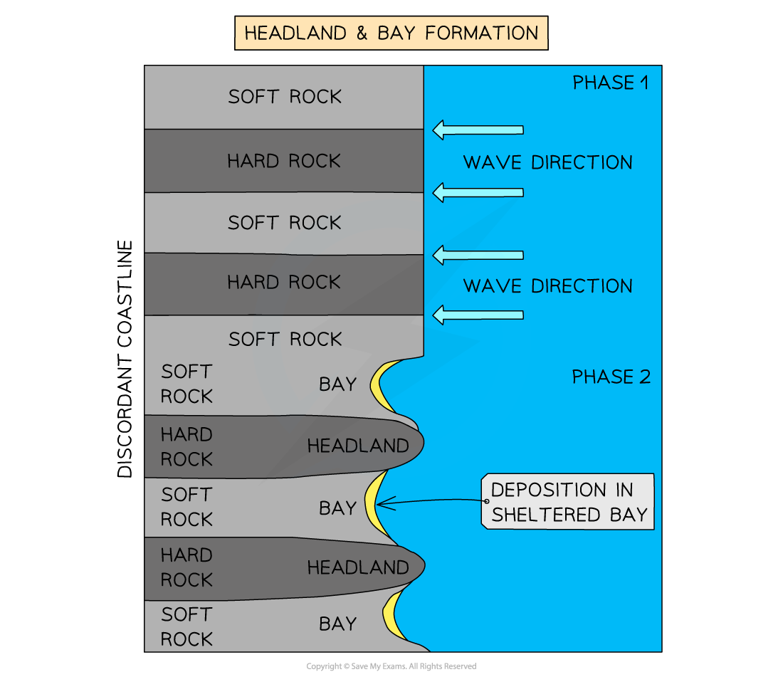
A headland usually features:
Cliffs along its sides
Projects out to sea
Usually longer than it is wide
Geology is of resistant rock
A bay usually has:
A wide, open entrance from the sea
A roughly, semi-circular shape extending into the coastline
Land that is lower than the headlands surrounding it
A bay may or may not have a beach
Caves, arches and stacks
As waves approach the shore, their speed is reduced as they move along the sea floor
This changes the angle of the waves, and they will turn so the crest becomes parallel to the coast - known as wave refraction
This refraction concentrates erosive action on all sides of the headland
Any weaknesses in the headland are exploited by erosional processes of hydraulic action, abrasion and corrosion
As the crack begins to widen, abrasion will begin to wear away at the forming cave
The cave will become larger and eventually breaks through the headland to form an arch
The base of the arch continually becomes wider and thinner through erosion below and weathering from above
Eventually, the roof of the arch collapses, leaving behind an isolated column of rock called a stack
The stack is undercut at the base by wave action and sub-aerial weathering above, until it collapses to form a stum
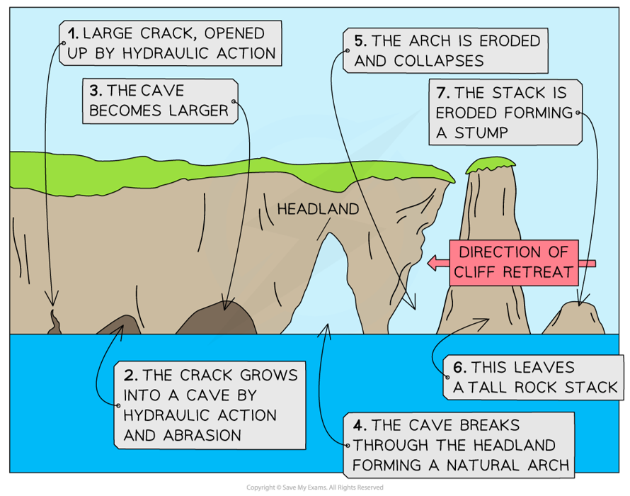
The formation of a cave, arch, stack and stump
Depositional Landforms
Depositional Landforms
Beach
Form in sheltered areas such as bays
Deposition occurs through constructive wave movement, where the swash is stronger than the backwash
Beach formation usually occurs in the summer months when the weather is calmer
Sometimes sand from offshore bars can blow onto the shore by strong winds
Blown sand can create sand dunes at the backshore of a beach
Spit
An extended stretch of sand or shingle that extends out to sea from the shore
Spits occur when there is a change in the shape of the coastline
Or the mouth of a river, which prevents a spit forming across the estuary
A spit may or may not have a 'hooked' end, depending on opposing winds and currents
A good example is Spurn Point, which stretches for three and half miles across the Humber Estuary in the northeast of England
Stages of formation:
Sediment is transported by the action of longshore drift
Where the coastline changes direction, a shallow, sheltered area allows for deposition of sediment
Due to increased friction, more deposition occurs
Eventually, a spit slowly builds up to sea level and extends in length
If the wind changes direction, then the wave pattern alters and results in a hooked end
The area behind the spit becomes sheltered
Silts are deposited here to form salt marshes or mud flats
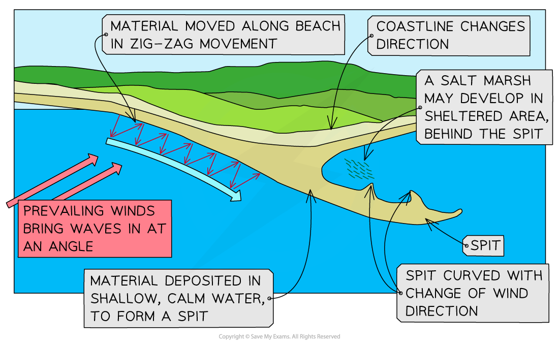
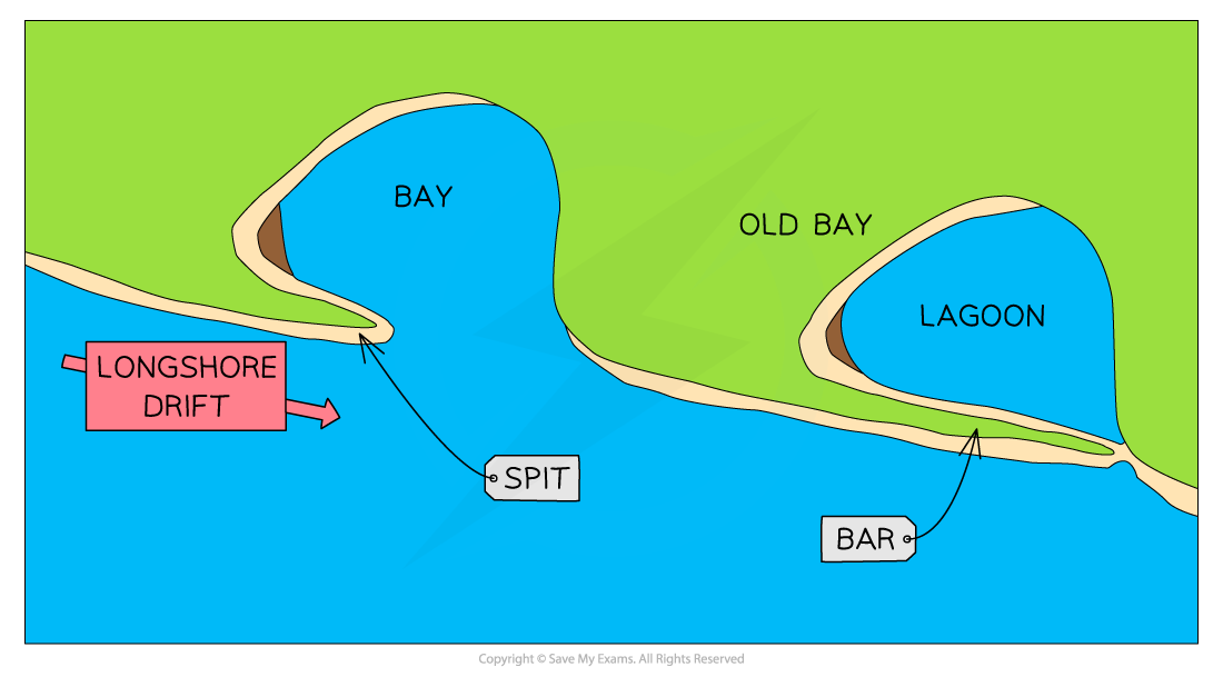
Formation of a Spit
Bar
When a spit grows across a bay, and joins two headlands together
A bar of sand is formed (sandbar)
Sandbars can also form offshore due to the action of breaking waves from a beach
Lagoon
A lagoon is where a small body of water is cut off from the sea
A lagoon may form behind a bar or tombolo
Lagoons do not last forever and may fill with sediment and form new land
Tombolo
A tombolo is formed when a spit joins the mainland to an island
Chesil Beach in Dorset is a tombolo, as the mainland is joined to the Isle of Portland
Barrier island
Barrier islands form parallel to the coast
The main difference between a bar and barrier island is that a bar joins two headlands, whereas a barrier island is open at one or both ends

Sand dunes
Sand dunes are a dynamic environment, with changes occurring quickly
Sandy beaches are usually backed by sand dunes due to strong onshore winds which transports dried out, exposed sand
Sand grains are trapped and deposited against an obstacle (rubbish, rocks, driftwood etc) to form dunes
Dune ridges move inland due to onshore winds pushing the seaward side to the leeward side
It is the interaction of winds and vegetation that help form sand dunes
Formation of a sand dune
Windblown sand is deposited against an obstruction - pebble or driftwood
As more sand particles are caught, the dunes grow in size, forming rows at right angles to the prevailing wind
Over time, the ridges of the dunes will be colonized and fixed by vegetation in a process called succession
The first plants (pioneer species) have to deal with:
Salinity
Lack of moisture as sand drains quickly (highly permeable)
Wind
Temporary submergence by wind-blown sand
Rising sea levels
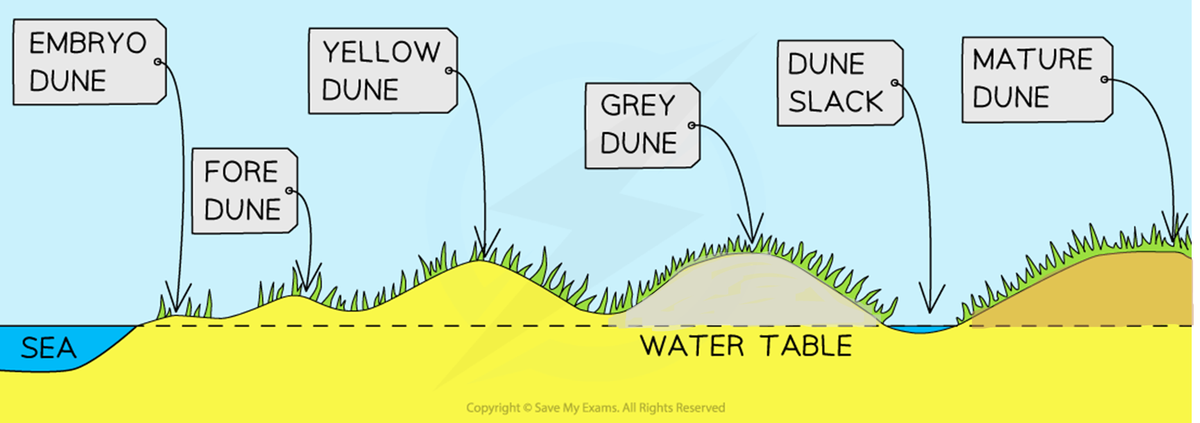
Coastal Dune Succession
Embryo dunes
Wind-blown dried sand is trapped by debris and deposition begins
Pioneer species such as Lyme Grass and Sea Couch Grass begin to colonise
There is little soil content and high pH levels (alkaline)
Embryo dunes are very fragile and reach a maximum height of 1 metre
Fore dunes
The embryo dunes bring some protection against the prevailing wind
This allows other species of plant to grow such as Marram Grass
Marram grass begins to stabilise the dune with its root system
These plants add organic matter to the dunes making the dunes more hospitable for plants that later grow
A microclimate forms in the dune slack
Maximum height is 5 metres
Yellow dunes
These are initially yellow but darken as organic material adds humus to the soil
Marram grass still dominates the vegetation, but more delicate flowering plants and insects are found in the dune slacks
20% of the dune is exposed, down from 80%
Height does not exceed 8 metres
Grey dunes
Grey dunes are more stable, with less than 10% of exposed sand and have a good range of biodiversity
Soil acidity and water content increase as more humus is added
Shrubs and bushes begin to appear
Height is between 8 - 10 metres
Mature dunes
As the name suggests, these are the oldest and most stable of the dunes
They are found several hundred metres or more from the shoreline
The soil can support a variety of flora and fauna such as oak trees and alders (climax vegetation)
This is the final stage in succession which is known as the climax community stage